Overview
Lake Area Waste Water Association (LAWWA) has retained Horner & Shifrin (H&S) to provide a secure, multi-user, and customizable GIS platform (Skyview GIS) allowing the LAWWA staff and their partner agencies to have real-time access to LAWWA asset features and data that is easy to deploy, backed up, and cost effective by utilizing desktop workstations/laptop and cellular enabled tablets/smartphones.
The H&S teams’ vast expertise and Skyview GIS platform allows LAWWA staff and their partner agencies to view, edit, integrate, migrate, upload, download, share, and analyze a wide range of source data and formats including district-provided paper-based plans, regulatory agency data, non-ESRI databases, shapefiles, geodatabases, tabular data, CAD files, GPS/GNSS survey data, aerial and mobile LiDAR data/photogrammetry, embedded data attachments (photos, videos, and PDF documents) and other third party GIS sources into a homogenous single source SDE geodatabase.
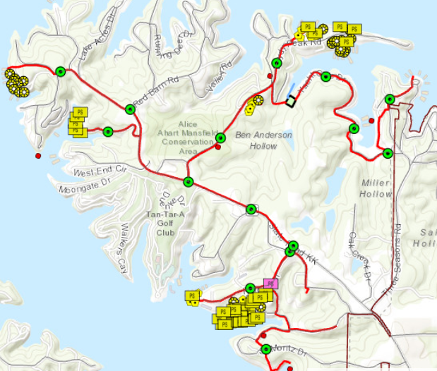
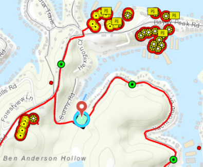
H&S adheres to the standards provided by LAWWA, so all parties are on the same page when collaborating. Standard forms and drop down menus ensure data integrity by providing preset values for LAWWA staff asset types such as manholes, clean outs, pump stations, pits, gravity and force mains, etc., along with providing the ability to view and/or edit the sanitary system, additional modules and asset data can be added to track the flushing of the sanitary system, smoke testing, basement backups, service request, rehab status, addresses, parcel data from any device. Use of survey-grade GPS units with centimeter accuracy ensures vertical accuracy of assets and the data collected would be reliable when imported into future modeling systems.
The integrity of GIS data is of paramount importance to run analysis, standards compliance, query data, filter for mapping purposes or share data with other parties. Utilizing advanced automated tools to ensure data integrity of imported data such as the ESRI Data Reviewer Extension, the H&S staff can create automated workflows, which can analyze entire data sets and find errors such as non-connected vertexes, overlapping polygons, inconsistent naming, null values, etc. This time saving process provides the ability to quickly, find, locate, and resolve targeting errors in database rather than reviewing all data, segment by segment.
Training and engagement of staff is crucial to the success of manipulating and maintaining the Skyview GIS platform. H&S provides on-site hands-on or virtual training sessions include a mix of office and field training along with providing step by step instructions on data integration, field application collection, data modifications, analysis, and data/map producing capabilities, which is performed on current data for real world experience and not training data. Annual training and support are included in the hosting contract at no additional cost. In addition to on-site support, H&S offers virtual office and online meeting support between our Analysts and the LAWWA staff. with access to documentation, ability to create support requests, and contact information for live support via phone, text, or email.