September 17, 2018
Technology Profile: 3D Scanning and Aerial Acquisition
Horner & Shifrin is leveraging technology to the advantage of our clients and teammates
As a firm, Horner & Shifrin has a history of using innovative techniques and technology to solve our clients’ toughest challenges. Today, we continue that tradition by employing high-tech solutions to everyday issues like performing surveys and dealing with out-of-date aerial imagery.
3D Scanning
3D Scanning, also known as LiDAR, comes in several forms, with a variety of applications in the AEC industry and beyond.
What is LiDAR?
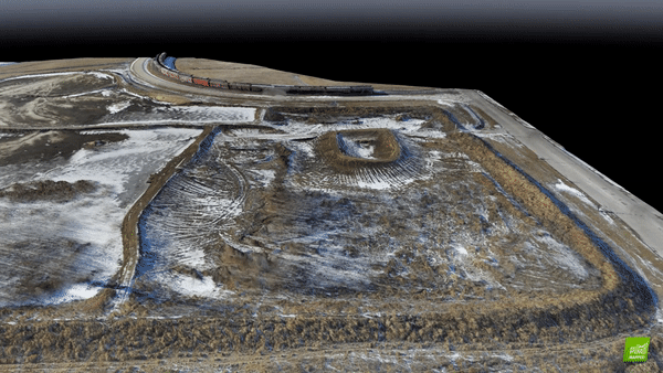
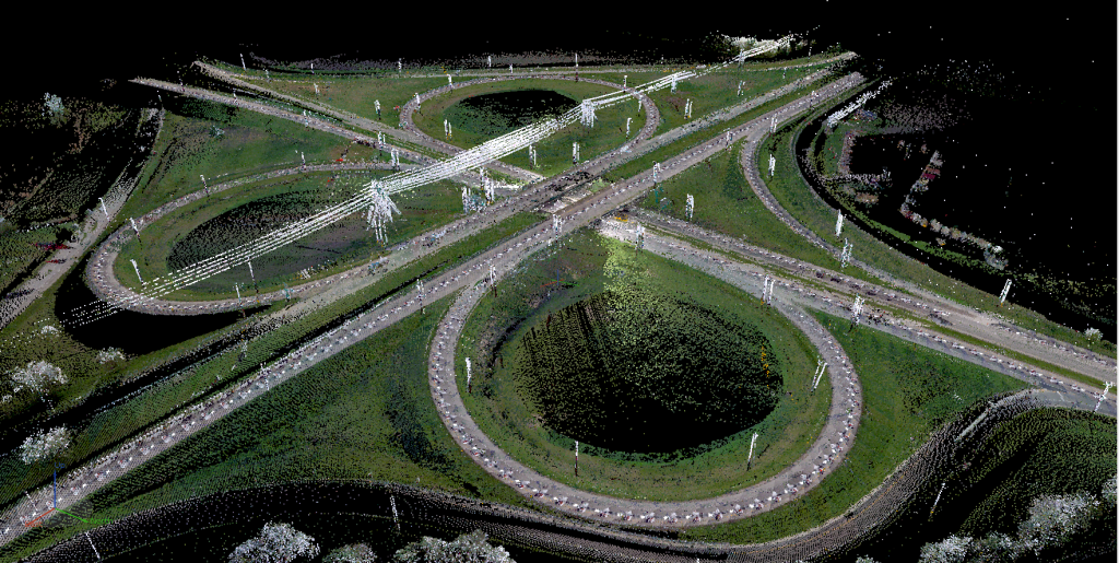
LiDAR, an acronym for Light Detection and Ranging, is a form of remote sensing used to capture geographic data. LiDAR can be used to capture data over a broad area in a short amount of time. A LiDAR instrument consists of a laser, a scanner, and a GPS receiver. When the laser is pointed at a targeted area, the beam of light is reflected by the surfaces it encounters. The scanner then records this reflected light to measure range. These laser ranges are combined with position and orientation data from the GPS receiver, resulting in a rich data set called a “point cloud.”
What type of equipment is used?
LiDAR instruments exist in several types with varying degrees of precision.
Terrestrial LiDAR instruments are used much like traditional survey equipment, with a single-point setup from which a scan is performed. This method yields an accuracy of +/- 1mm, but requires multiple setups to capture points that are out of the initial scan’s line of sight.
Mobile LiDAR instruments are portable, vehicle-mounted setups accurate to +/- 6mm. This method offers the convenience of shooting roadways at a regular speed (~55 mph), eliminating field staff exposure to potentially unsafe conditions. Instruments can also be mounted to utility vehicles for trail mapping or hi-rail trucks for railway survey.
Handheld LiDAR instruments offer the portability of mobile with the access of terrestrial. With an accuracy of +/- 2.5cm, this method is a quick and easy way to perform interior scans without disrupting a job site.
Scans from multiple setups and methods can be combined into one point cloud based on georeferenced control points.
What is the result?
After a LiDAR scan is performed, our skilled technicians clean up the data to deliver a 3D georeferenced point cloud that can be colorized specifically based on elevations or combined with colors from still photos taken by the scanner, resulting in a point cloud with a photo-like appearance.
How can the captured data be used?
Quickly capture data across a large project site or route. Perform pavement inventories, vertical clearance surveys, asset collection, and condition assessments from the office by limiting the time spent in the field. Reduce the frequency of your visits to a project site by creating a 3D model that can be referenced at any time.
Aerial Acquisition
Aerial acquisition refers to the capture of photos and video from the airspace above a location. Horner & Shifrin has an FAA Part 107 Certified UAS Pilot on staff to coordinate and manage aerial acquisition as part of ongoing projects and as a stand-alone service.
What is Photogrammetry?
Photogrammetry is the science of using photographs to make measurements. Distances between points and ground elevations can be determined simply by combining multiple overlapping photos taken at the same angle.
What type of equipment is used?
Horner & Shifrin employs two pieces of equipment to perform aerial image and video acquisition. Both are types of unmanned aerial systems (UAS), which are commonly referred to as drones.
A quadcopter UAS is a device that functions like a helicopter but uses four rotors to generate lift. The system features an under-mounted camera on a 3-axis gimbal, with the ability to shoot photos and video from the horizon down to the ground in a 90° range. No larger than a hat box and weighing less than 5 lbs, the quadcopter can be used in tight spaces and around buildings.
A fixed-wing UAS is a device resembling a small airplane, with a single rear-mounted propeller. Made from rigid styrofoam with a total weight less than 2 lbs and a wingspan around 4 feet, the machine is low-profile and easy to deploy. A single camera mounted inside the body faces straight toward the ground.
What is the result?
Depending on the desired application, the method will be selected prior to capture, resulting in a deliverable of photos and/or video. Using aerial photography, a 3D model of a site or building can be constructed. Contours can be exported for a variety of uses.
How can the captured data be used?
Up-to-date aerial imagery can be used in GIS to for asset location and management. 3D models can be used to perform accurate site surveys. Contours can provide valuable data for stormwater management. Video can be reviewed to perform exterior inspections of roofs, water tanks and other locations that may be difficult to reach.